| TYPE | 2026 | AVG | DIFF |
| Total: | 104 | 79 | +32% |
| EMS: | 72 (69%) | 58 (73%) | +24% |
| Fire: | 22 (21%) | 15 (19%) | +47% |
| Other: | 10 (10%) | 6 (8%) | +67% |
Pierce County Fire District #23 sits at the base of Mount Rainier, one of the most hazardous active volcanoes in the world because of its proximity to large populations downslope of the volcano. Mount Rainier has a wide suite of hazards, but the most destructive and far reaching hazard that could potentially impact district residents are lahars.
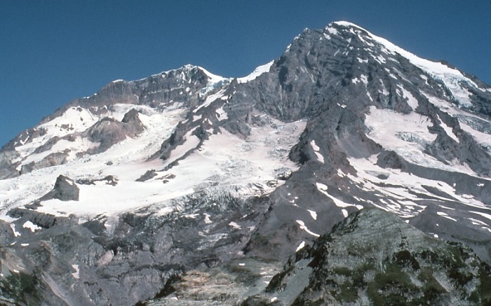
The word lahar is an Indonesian term that describes a rapidly flowing mixture of water and rock fragments that rushes down the slopes of a volcano and its river valleys most often during volcanic eruptions. Lahars also form by the collapse of weakened rock on the side of a volcano. Except for their much larger size, lahars behave a lot like the small seasonal events in some streams at Mount Rainier, which usually do not leave the park boundary and are referred to as "debris flows".
A moving lahar looks like a roiling slurry of wet concrete, and as it rushes downstream, the size, speed, and amount of material carried can constantly change. The initial flow may be relatively small, but a lahar may grow in volume as it entrains and incorporates anything in its path – rocks, soil, vegetation, and even buildings and bridges. The flowing slurry may consume additional water through melting of snow and ice or by engulfing river or lake water. Voluminous lahars commonly grow to more than 10 times their initial size as they move downslope. In steep areas, lahars can exceed speeds of 200 km/hr (120 mi/hr), but as they move farther away from a volcano and decelerate in lowland areas, they eventually begin to deposit some of the load and decrease in size.
Some areas within Pierce County Fire District #23 are also at risk from lahars formed by massive collapses of rock on the west side. These lahars can happen without volcanic eruptions. Lahar events are not predictable. The normal symptoms of a reawakening Mount Rainier, as reported by volcano monitoring devices, should provide us with ample warning for most lahars, but not all. That is why it is important to know actions to take during an actual event.
Hearing loud roaring sounds from up valley...
Seeing a rapid rise in a river or stream, and/or...
Feeling the ground rumbling beneath your feet...
SEEK HIGH GROUND IMMEDIATELY!
In the Nisqually River valley, rocky layers from the 2,200-year old National Lahar cover parts of the valley floor. The most recent lahar descended into the Nisqually valley around 500 years ago part of the Electron Mudflow. In 1947, a debris flow from Kautz Glacier buried the park road crossing with 28 feet of mud, and some mud was deposited in Alder Reservoir.
This USGS site has a lot more information about Lahars.
Additionally, the Pierce County Active Volcano website has a wealth of information about preparing for a volcanic emergency.
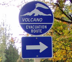
The map below shows some of the designated evacuation routes (paths in the Blue Color) for District 23's coverage area in the event of a lahar from Mount Rainier. If you live in the district, please be familiar with the route nearest you as well as the general routes for the entire area.
Keep a lookout for the blue Volcano Evacuation Route Signs shown to the right for possible evacuation routes while you travel around the Mount Rainier area. These signs direct you to safe locations if a geologic event were to occur.
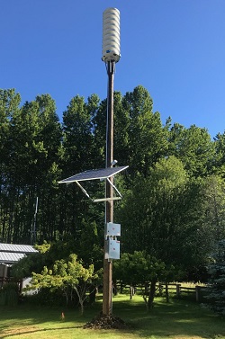
All Hazard Alert Broadcast (AHAB) Sirens are one aspect of that pre-planned emergency response in Pierce County. When imminent danger threatens, the outdoor sirens will be activated. Citizens will be advised to evacuate the valley floor and head to higher ground. The sirens are made for outdoor warning and used to alert residents of the need to evacuate due to a lahar or other volcanic event. The outdoor sirens are tested at noon on the first Monday of every month. The outdoor sirens wail for approximately five minutes during the testing. During a real event, the outdoor sirens will continuously wail until the batteries die or they are destroyed.
There are currently three AHAB Sirens within District 23 boundaries: One each in the geographic areas of Alder, Ashford and Elbe. Their locations are shown on the evacuation map above and a photo of the Ashford siren is shown to the right.
As of CASCADES VOLCANO OBSERVATORY WEEKLY UPDATE
Friday, January 5, 2024, 1:47 PM PST (Friday, January 5, 2024, 21:47 UTC)
CASCADE RANGE (VNUM #)Current Volcano Alert Level: NORMALCurrent Aviation Color Code: GREENActivity Update: All volcanoes in the Cascade Range of Oregon and Washington are at normal background activity levels. These include Mount Baker, Glacier Peak, Mount Rainier, Mount St. Helens, and Mount Adams in Washington State and Mount Hood, Mount Jefferson, Three Sisters, Newberry, and Crater Lake in Oregon.Past Week Observations: During the past week, small earthquakes were detected at Mount Rainier and Mount St. Helens. All monitoring data are consistent with background activity levels in the Cascades Range.The U.S. Geological Survey Cascades Volcano Observatory and the University of Washington Pacific Northwest Seismic Network continue to monitor Washington and Oregon volcanoes closely and will issue additional notifications as warranted.Website ResourcesFor images, graphics, and general information on Cascade Range volcanoes: https://www.usgs.gov/observatories/cvoFor seismic information on Oregon and Washington volcanoes: http://www.pnsn.org/volcanoesFor information on USGS volcano alert levels and notifications: https://www.usgs.gov/programs/VHP/volcano-notifications-deliver-situational-information
This page only provides a limited amount of information about lahars and geologic hazards in our district. To learn more, please visit the following pages to gain an understanding about Lahars, evacuation routes, and how to safely live next to an active volcano:
- USGS - What is a Lahar
- Lahar Sirens in Pierce County
- Mount Rainier Geology and Weather
- Pierce County - Mount Rainier Active Volcano Website
- United States Geological Survey (USGS) Cascades Volcano Observatory (CVO)
- USGS Cascades Volcano Observatory Weekly Update
- Pacific Northwest Seismic Network (PNSN)
- USGS Earthquake Hazards Program
- WA DNR - Volcanoes and Lahars
- USGS Volcano Notification System